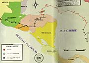
Mitch route
report: INETER
Belize
Costa Rica
El Salvador
Guatemala
Honduras
Nicaragua
Panama
Hurricane Mitch was reported in real-time and in the monthly bulletins in October-November 1998 in detail by the national meteorological services in the Central American isthmus. A detailed report on the rainfall and cyclone activities in Nicaragua in 1892-1998 was published in December 1998 by INETER, the national meteorological service of Nicaragua. A draft summary report on the role of the NMSs during Mitch and the strength of the hurricane was compiled by the regional committee CRRH in early January 1999.
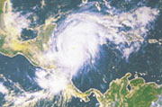
The development and movement of hurricane Mitch from 21st October to
5th November 1998 was the following as presented under the headline ōthe
hurricane called Mitchö in the monthly weather bulletin of the national
meteorological service of Belize, October 1998:
ōMitch formed in the SW Caribbean Sea from a tropical wave about 360
miles south of Kingston, Jamaica, late on the 21st October 1998. The system
initially moved slowly westward and intensified to a tropical storm. Mitch
then moved slowly northward, then north-northwestward on the 23rd and 24th
and gradually strengthened. Mitch became a hurricane early on the 24th.
Later that day, as Mitch turned toward the west, it began to intensify
rapidly. In about 24 hours its central pressure dropped by 52 Mb. Further
strengthening took place and the central pressure reached a minimum of
905 Mb about SW of Swan Island on the afternoon of the 26th. This pressure
is the fourth lowest ever recorded in an Atlantic hurricane this century
¢ tied with Camille in 1969.
This also represents the lowest pressure ever recorded in an October
hurricane in the Atlantic basin this century. At this peak intensity, Mitch´s
one-minute maximum sustained surface wind was estimated at 180 mph. A category
five hurricane on the Saffir/Simpson scale.
Mitch began to weaken gradually after passing Swan Island on the 27th,
as it moved westward then southwestward toward the bay islands of Honduras.
The center passed very near the island of Guanaja, wreaking havoc there
as well as on the neighboring island of Roatan. From mid-day on the 27th
to early on the 29th, the central pressure rose 59 Mb. The center of the
hurricane meandered near the north coast of Honduras, then it moved southward
and inland, weakening to a tropical storm on the 29th. Mitch moved slowly
over Honduras and Guatemala on the 30th and 31st and weakened further to
a tropical depression. The weakening produced torrential rains over portions
of Honduras, Nicaragua, Guatemala, El Salvador and Belize. The associated
floods were devastating in Honduras and Nicaragua.
Although Mitch originally dissipated near the Guatemala/SE Mexico border
on Sunday afternoon, November 1st, the remnants continued to produce locally
heavy rainfall over portions of Central America and eastern Mexico during
the next couple of days. Mitch re-emerged as a low-level circulation in
the Bay of Campeeche. An airforce reconnaissance aircraft reported tropical
force winds and a central pressure of 997 Mb in that area. Mitch had regenerated
into a tropical storm on the afternoon of the 13th November, some 55 miles
WSW of Campeeche, Mexico.
Mitch weakened to a tropical depression early on the 4th as it moved
inland over northwestern Yucatan. The center re-emerged over the south
central Gulf of Mexico by midmorning on the 4th, regaining tropical storm
intensity. Mitch then began to accelerate toward the NE as it interacted
with a cold front moving through the southeast gulf of Mexico. Mitch made
landfall on the morning of the 5th over SW Florida near Naples, with maximum
sustained winds near 60 mph. Mitch then moved offshore southern Florida
by midafternoon of the 5th, and became extra tropical.
WMO arranged a coordination meeting for emergency assistance in San José, Costa Rica, on 19-20 January 1999 with international financing agencies, national meteorological services in the Central American isthmus and in the Caribbean countries and with WMO/VCP donors. The international support programme for 1999 will be defined in detail before the next hurricane season (June 1999). The regional support programme of the Project for 1999 coordinated by CRRH is foreseen to be partly readjusted, accordingly.